American Chestnut Land Trust

a land conservancy

  • Home
  • About
    • What We Do
    • Staff and Board
    • Mission and History
    • Reports, Publications and Slides
    • ACLT Blog
    • Latest Newsletter
    • Newsletter Search Page
    • ACLT Press Kit
    • Contact Us
  • Climate Change
  • Land & Maps
    • Trails and Trailheads
    • Double Oak Farm
    • The Land
    • Watershed Ecology
    • Parkers Creek Heritage Trail
    • Cultural History
  • Support ACLT
    • Ways to Support ACLT
    • ACLT Merchandise
    • General Donation
    • Join/Renew Membership
    • Friends Forever – Planned Giving
    • ACLT’s Sponsors
  • Get Involved
    • Become a Volunteer
    • Volunteer Hours
    • Calendar of Events
    • Conserve Your Land
    • Southern Maryland Conservation Alliance
    • Watershed Friends Groups
      • Friends of Hunting Creek
      • Friends of St. Leonard Creek
      • Friends of Mill Creek
      • Friends of Fishing Creek
      • Friends of Hall Creek
  • Join/Renew
  • Donate
Home / Archives for SMCA Blogs

The Rills are Alive….With Strands of DNA

July 27, 2023 By Community Relations Manager

By Ron Klauda, Mary Hoover, and Evan Klauda


With apologies to Julie Andrews and “The Sound of Music” for the titular pun, we want to tell you about an exciting biological sampling tool tested by the Friends of Hunting Creek (FOHC) for the first time in Calvert County streams (or rills, if you prefer).  Taking inspiration and encouragement from Dr. Chris Rowe (Associate Professor, Chesapeake Biological Lab), we conducted a pilot study using eDNA sampling in four non-tidal streams in the Hunting Creek watershed.  

What is eDNA and how can it describe biodiversity?

Environmental DNA, or eDNA, is the genetic material shed by fish and other aquatic animals into the streams, rivers, ponds, lakes, estuaries, wetlands, and oceans where they live. By carefully collecting water samples that contain mucus, skin, scales, other tissues, urine, and yes, even ‘poop’, scientists can extract and process eDNA to learn who lives where.

There is a growing consensus among the scientific community that eDNA analysis is a complementary and perhaps an emerging alternative approach to traditional sampling methods. eDNA analysis is often an easier, quicker, and cheaper way to reliably describe fish communities in a stream. There is also considerable evidence to support using eDNA concentrations as an ancillary tool for estimating fish species composition and abundance, in addition to mere diversity.  eDNA-based methods are revolutionizing biodiversity monitoring by enabling non-invasive, efficient, and less costly surveys of diverse taxa in aquatic ecosystems. The FOHC has neither the equipment nor the staff needed to sample stream fishes using traditional sampling gear, so eDNA sampling offered us a doable approach.

To learn more about this innovative sampling tool, check out this short video from “down under.”

What do we want to learn from our pilot study?

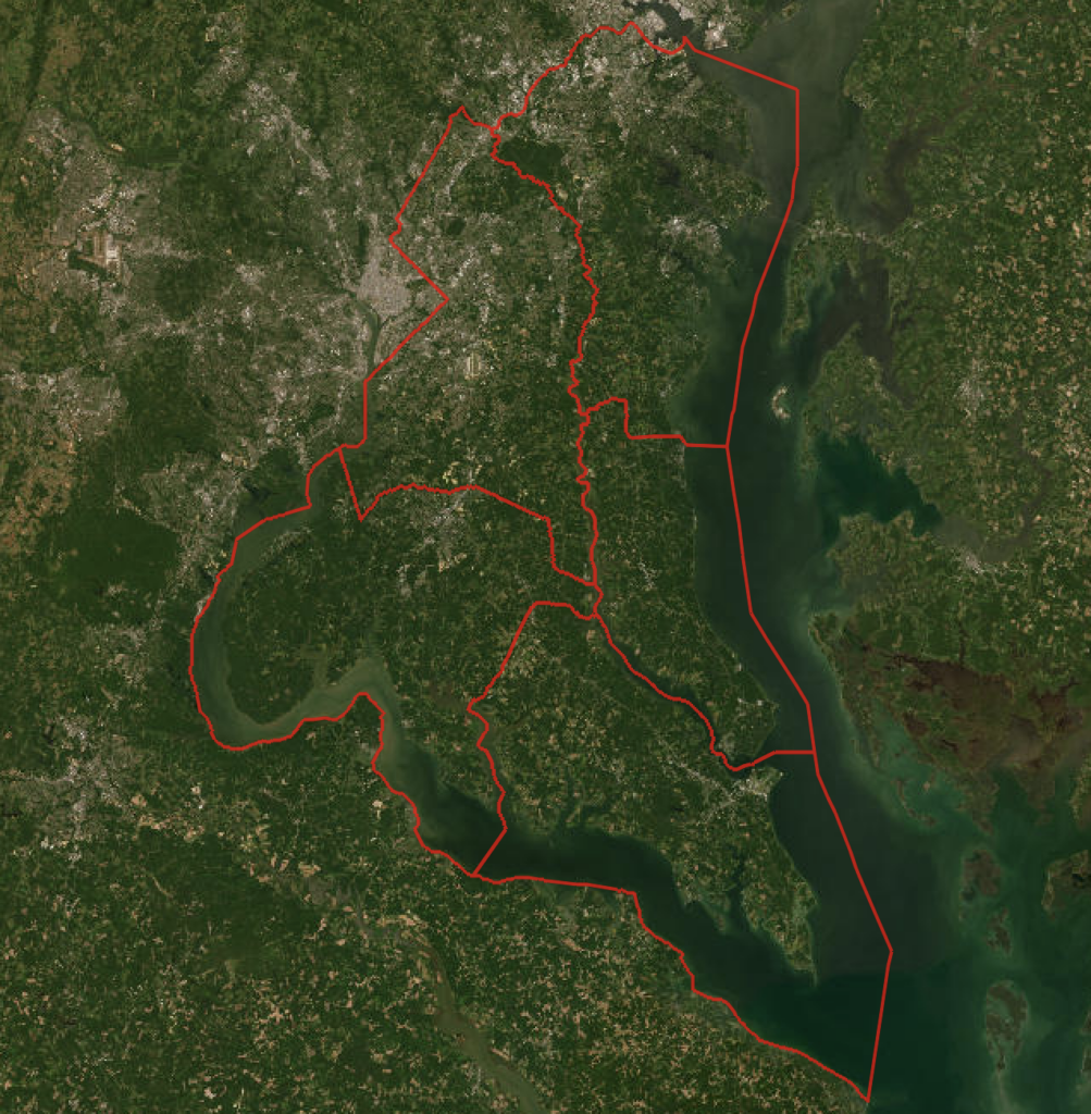
Our goal was to determine if eDNA analysis can tell us what fish species call the Hunting Creek watershed home.  To better understand and protect the largest watershed in Calvert County (almost 20,000 acres), the FOHC needs to know what lives in the watershed’s 50 or more miles of streams.  How many fish species live in these streams and which ones are most common?  Are there any rare species in need of special protection?  Are there non-native, invasive fish species that could pose a threat to native species?  We asked eDNA sampling to help us answer these important questions.

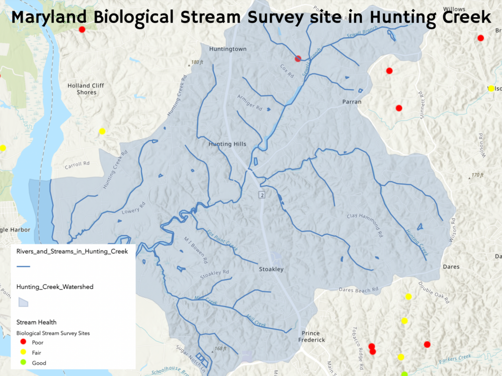
After consulting Maryland DNR’s Stream Health Map, we were surprised to learn there is only one site in the Hunting Creek watershed where fish were collected by the Maryland Biological Stream Survey (MBSS): an unnamed tributary to Sewell Branch that the FOHC unofficially call “Barberry Branch.” Sampled by the MBSS in 2004, only three fish species were collected at this site: Eastern Blacknose Dace, Eastern Mudminnow, and Tessellated Darter. For comparison, the MBSS  has sampled and collected fish at 9 sites in the Parkers Creek watershed. 

Stream site in Hunting Creek Watershed tested by Maryland Biological Stream Survey (MBSS). Image taken from Maryland Department of Natural Resources.

Where, when, and how did we collect eDNA samples?

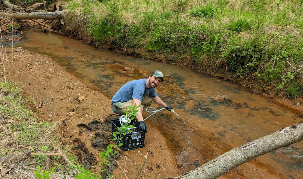
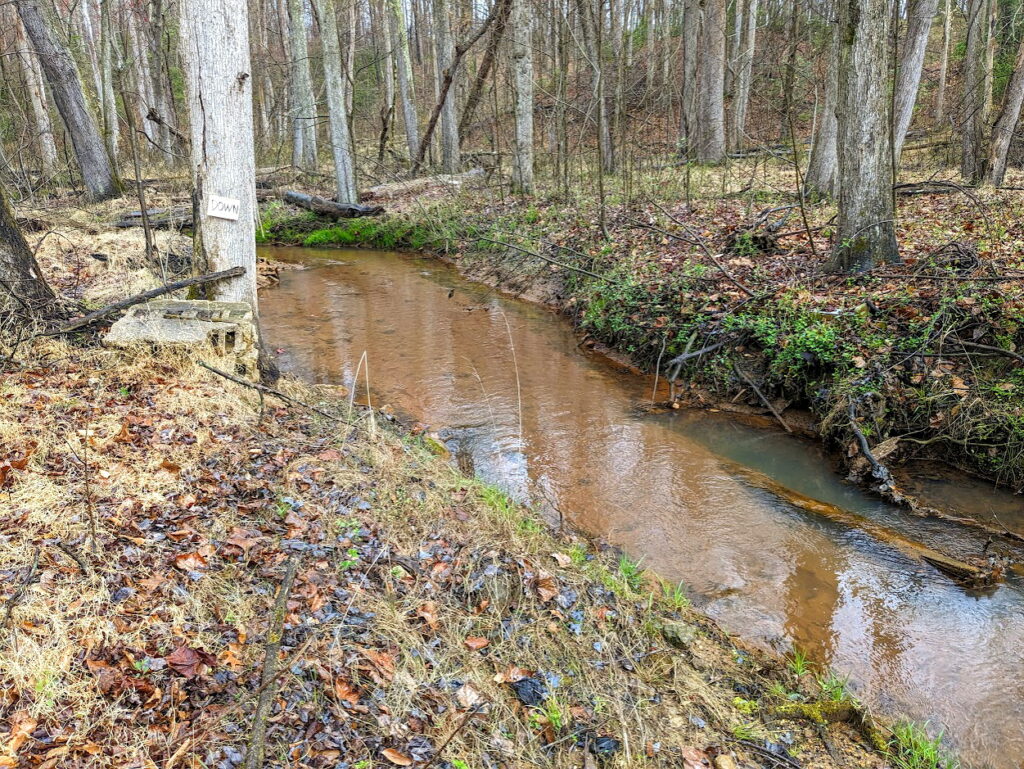
Water samples were collected in mid-April 2023 in four streams using a Smith-Root eDNA Citizen Scientist sampling pump and their Self-Preserving Filter Packs with micron mesh filters.  Two water samples were collected in each stream, along with two distilled water field blanks to check for possible on-site contamination in sample handling.

Evan Klauda taking an eDNA sample from Fox Run Creek.

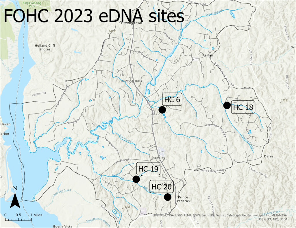
The four pilot study streams were HC6 (Fox Run), HC18 (unofficially called “Chingaware Run”), HC19 (an unnamed tributary to Mill Creek), and HC20 (upper Mill Creek).

All sites sampled for eDNA by the Friends of Hunting Creek in 2023.

How were the eDNA samples processed?

After collection, the filter packs were mailed to Jonah Ventures for analysis.  The DNA was extracted, amplified, sequenced, and then the found sequences were compared to known DNA sequences to determine what fish species were present in each sampled stream.  

Allow us to elaborate a bit.  As you may recall from that Biology 101 course you took, strands of DNA are made up of four bases: adenine (A), guanine (G), cytosine (C), and thymine (T).  Every organism has its own unique pattern of A, G, C, or T sequences.  Scientists at Jonah Ventures labeled each base sequence in a process called metabarcoding.  DNA sequences in our stream water samples were compared to other sequences in large DNA databases (think library or fingerprint file) to identify individual fish species.   

Rob Aguilar (Research Technician, Smithsonian Environmental Research Center) kindly ‘tweaked’ (our word, not his) the spreadsheet we received from Jonah Ventures, using SERC’s private reference sequence library (CBBI: Chesapeake Bay Barcode Initiative),  and improved our confidence in the species identifications.

What have we learned so far?

1.Well, for starters, we now know how to collect uncontaminated water samples from streams for eDNA analysis. Jonah Ventures found no DNA in our two field blanks. 

2.We also now know what fish species live in the four streams we sampled.  For brevity’s sake, this article will share only what we learned about Fox Run (HC6).  eDNA results for the other three streams sampled in our pilot study will be discussed in the FOHC’s 2023 water quality monitoring report currently being prepared.

Fox Run stream site for eDNA.

eDNA analysis told us that Fox Run is home-sweet-home to at least the following 16 fish species, in alphabetical order: 

American Eel, Bluegill, Brown Bullhead, Chain Pickerel, or Redfin Pickerel. Creek Chubsucker, Eastern Blacknose Dace, Eastern Mosquitofish, Eastern Mudminnow, Golden Shiner, Green Sunfish, Largemouth Bass, Redbreast, Sunfish or Pumpkinseed, Satinfin Shiner, Spottail Shiner, Tessellated Darter, and Yellow Bullhead, more species found by eDNA analysis than in any of the other three streams. 

eDNA analysis could not distinguish Chain Pickerel from Redfin Pickerel, or Redbreast Sunfish from Pumpkinseed.  All 16 species are native to some portion of Maryland. None are rare, threatened, or endangered. The three most common fishes found in Fox Run were Tessellated Darter (#1), Creek Chubsucker (#2), and Golden Shiner (#3).  

Satinfin Shiner and Spottail Shiner are categorized by MD/DNR as intolerant/pollution-sensitive species found only in good quality streams.  Spottail Shiner is also a lithophilic spawner, meaning their eggs develop in the cracks and crevices of clean sand, gravel, and cobble substrates.  Hence, sediment deposition that buries the developing eggs greatly diminishes their spawning success.  Redfin Pickerel is somewhat sensitive to pollution and found only in fair to good quality streams.  The rest are more pollution tolerant/less sensitive and found in any quality stream.

3. Perhaps most important for this Pilot Study, eDNA analysis did not find any “oddball” fish species (e.g., Sockeye Salmon) that should not live in the Hunting Creek watershed.  Our results from four streams suggest that the ‘DNA fingerprint files’ for Coastal Plain Maryland stream fish are robust and reliable.

How does fish diversity in Fox Run compare to other Calvert County streams?

The short answer is, “The highest!”  Compared to all other County streams that were sampled by the MBSS, Fox Run has the most fish species (16).  Coming in second, to date, is a site in Lyons Creek (sampled in 1997) with 15 species, including 5 species that eDNA analysis did not find in Fox Run:  Fallfish, Least Brook Lamprey, Rosyside Dace, Tadpole Madtom, and Yellow Perch.  

In case you’re wondering, 14 fish species have been collected among 9 sites in 5 Parkers Creek tributaries, including a non-native species: Northern Snakehead.   

What’s Next?

Fox Run flows north behind the Fox Run Shopping Center and Calvert Health Medical Center, areas with many acres of paved parking lots, roadways, and rooftops.  These non-absorbing (impervious) surfaces make stormwater management very challenging.  Many studies have shown that impervious surfaces can be “stream killers.”  Further development is being planned in the upper portions of the Fox Run watershed (e.g., Magnolia Ridge residential complex), which could threaten a stream fish community that appears to be the most diverse in Calvert County.  The FOHC will continue to be vigilant and work diligently to protect Fox Run and all streams in the Hunting Creek watershed.

In addition to presenting the fish eDNA results for the other three streams included in our pilot study, the FOHC’s 2023 water quality report will also present eDNA results for benthic macroinvertebrates that were collected in the four streams sampled for fish diversity. 

Share

Filed Under: SMCA Blogs, Uncategorized

USFWS Land Protection Plan received positively by Southern Marylanders

April 19, 2023 By Community Relations Manager

The U.S. Fish and Wildlife’s plan to establish a new wildlife refuge in Southern Maryland was positively received by the public at the last of three listening sessions on Tuesday, April 18th. Held at the Calvert Marine Museum in Solomons, the event was attended by mainly Calvert County residents, but the nearly full house of attendees had representation from all over Southern Maryland. 

The three listening sessions have been a way for the Service to engage public input in the rollout of the plan, complying with the National Environmental Policy Act (NEPA), which requires a public scoping period. The purpose of the meetings was to inform the relevant communities about the Land Protection Plan/ Environmental Assessment (LPP/EA) being drafted for establishing a refuge, provide the rationale behind the proposed acquisition boundary, and answer any questions the public might have. While the Service was well prepared to assuage worries about the plan, such as how it might affect private property within the acquisition boundary, there was very little discourse at any of the three sessions that stemmed from criticism or concern. The reaction from the audience at Tuesday’s session was overwhelmingly positive, with most comments being inquiries about the logistics of the plan or words of support. 

Once completed, the draft plan will be released to the public for a 45 day review period, where more comments will be welcomed. The finalized plan must be approved by the USFWS director, after which the Service may begin seeking properties from willing sellers to compose the new national wildlife refuge. See the presentation from the listening sessions here.

Dan Murphy, Chief of the Division of Habitat Conservation for the USFWS' Chesapeake Bay Field Office, presents a map of existing refuges in Maryland.
A nearly full house of attendees listens to introductions from Jennifer Greiner, Manager of the Patuxent Research Refuge

Now that the listening sessions are completed, the Service invites the public to send comments for consideration in the final draft of the LPP/EA.

Email: FW5southernmarylandplan@fws.gov
Project Website:
https://www.fws.gov/project/proposed-new-refuge-lands-southern-maryland

Share

Filed Under: SMCA Blogs, Uncategorized

Listening Sessions to be held for a Southern Maryland Land Protection Plan

March 27, 2023 By Community Relations Manager

By Mary Hoover, SMCA Coordinator

It is well established that the Southern Maryland region is one of indispensable ecological importance. The Nature Conservancy’s Resilient Land Mapping Tool (below) reveals that the five county expanse houses some of the state’s most resilient landscapes, making this an opportune region for those who wish to conserve their lands. The green hues painting the Southern Maryland region on the map signify a landscape with abundant biodiversity and habitat connectedness, starkly contrasting the dark grays and browns that characterize the highly developed D.C. region. Although the Southern Maryland region currently houses some of the state’s most diverse species and connected lands, it is not guaranteed to stay this way. So long as land remains unprotected, the region is vulnerable to the omnipresent threat of the expansion of the D.C. Metro area. The good news is that ACLT, the Southern Maryland Conservation Alliance (SMCA), and the wider land trust community are working hard to preserve as much land as possible to maintain the environmental integrity of our critical region.

An exciting opportunity to amplify the scale of land protection in Southern Maryland is underway.  The U.S. Fish and Wildlife Service proposes the creation of a new wildlife refuge in Southern Maryland, and SMCA is assisting with the preparation of a Land Protection Plan/Environmental Assessment (LPP/EA) to do so. In short, the Land Protection Plan details the rationale for establishing a refuge in Southern Maryland, including a map of the acquisition boundary (the draft of which is below) and why it supports the USFWS mission to protect fish and wildlife habitat. If approved, the plan will greenlight USFWS pursuit of land from willing sellers within the acquisition boundary.

As of March 2023, the Service is in the process of drafting the plan and actively soliciting public input before seeking the document’s approval from the USFWS director. The approval of this plan could be a critical juncture for land preservation in Maryland. There has never been a more urgent time to protect Maryland’s most ecologically resilient lands, and an approved LPP/EA for Southern Maryland could greatly accelerate land protection by allowing USFWS to purchase via fee or easement up to 30,000 total acres of land within the acquisition boundary.

In September 2022, USFWS held a meeting to engage stakeholders and hear feedback about the proposal. On March 23, 2023, the Service held the first of three public listening sessions to further engage public opinion before finalizing the proposal. Between the two sessions, one of the most notable recurring concerns was how landowners would receive the plan. The term “acquisition boundary” may seem threatening to those whose properties fall within the border, but USFWS wants to be clear that the establishment of an acquisition boundary actually presents an opportunity. Joe McCauley, Chesapeake Fellow at the Chesapeake Conservancy and member of the LPP/EA core team, explained at the March 23 session that “this plan gives the Service the same right as everyone in this room, which is the right to purchase land from willing sellers.”  The plan, although necessarily laced with technical terminology, is as simple as this. 

Two more public listening sessions are scheduled for March 30 at the St. Charles County Administration Building in La Plata and April 18 at the Calvert Marine Museum in Solomons. Both sessions will be from 7-8pm, with ample time to ask questions. Public support is highly important to the Service, and this is a great opportunity for Southern Maryland citizens to inform their consent and offer valuable feedback, making the final proposal as effective as possible. 


For more info., view the FAQs here: www.acltweb.org/SoMdRefugeFAQ

Share

Filed Under: SMCA Blogs

Think Southern Maryland

January 26, 2023 By Community Relations Manager

Think Southern Maryland? Think big rivers, deep deciduous forests, abundant ecological services, and a rich cultural heritage. 

Bounded on the west by the Potomac and on the east by the Chesapeake Bay, Southern Maryland is teeming with ecological diversity. The Patuxent, Maryland’s largest river with headwaters in the state, courses through the center of Southern Maryland, touching all five counties. Maryland’s first capital, St. Mary’s City, as well as its current capital, Annapolis, are located in Southern Maryland, so it’s no surprise that much of the early history of both the state and the country transpired in this region. 

Early colonists settled in Southern Maryland for its temperate climate, rich farmland, and abundant access to waterways. However, the region’s history extends far before the arrival of colonists. The Piscataway Confederacy had already established villages and practiced a very sustainable form of agriculture that we could learn from today. 


Maryland’s history is inextricably tied to its landscape. Naturally, so are its current culture and economy inseparably linked to the land. Southern Maryland’s waterways are ideal for boaters and fishermen. Its deciduous forests are the largest in the state, supporting a wide variety of wildlife, a timber harvest industry, and dozens of miles of hiking trails dotted throughout the region. 

 However, one of the most indispensable components of Southern Maryland’s landscape is also one of its most overlooked. The region’s “green infrastructure” provides critical ecological services for the benefit of all people. The forests, meadows, bogs, and marshes attenuate stormwater, soak up excess nutrients, store carbon, and provide habitat for the smallest to the largest animals in the region. According to Maryland Greenprint maps, this green infrastructure provides $1.74 billion per year in ecosystem services to Southern Maryland. Our working landscapes add $3.2 billion to the regional economy.


Unfortunately, this green infrastructure is growing dangerously thin, as hunters, fishermen, farmers, and land stewards can attest. Already, Maryland has seen extensive land loss from development, and the future land loss projections are similarly bleak. In 2022, the American Farmland Trust published a report titled “Farms Under Threat 2040,” which predicted the three most likely scenarios for future farmland conversion in the United States. For Southern Maryland, the numbers are shocking. With steady “business as usual” landscape conversion, the five county Southern Maryland region is projected to lose 40,500 acres of farmland to development by 2040. However, the most popular development trend of recent years has been a low density, single use zoning model known as urban sprawl. Should this trend continue, Southern Maryland’s landscape is at risk of succumbing to “runaway sprawl,” which could cost us 58,800 acres of farmland, according to AFT.

Land is a finite resource, and the green infrastructure provided by natural landscapes is not easily renewed. Once gone, replacing it becomes very expensive, if not impossible. To counteract development pressures and ensure our region’s most valuable green infrastructure is permanently protected, we need aggressive action from land conservationists. For this reason, the Southern Maryland Conservation Alliance (SMCA) was formed in 2021 to strengthen the efforts of conservation actors in the five-county Southern Maryland region. With more than 35 affiliate organizations, SMCA aims to not only ramp up the pace of land preservation in the region, but also redirect the conversation surrounding rural lands and their multifarious benefits.


With the Biden Administration’s goal to preserve 30% of the U.S.’ natural lands by 2030, this is a ripe opportunity to reimagine the way we interact with and relate to land. Rather than valuing land foremost for its development potential, SMCA hopes to reinforce the intrinsic value of natural landscapes to people, the economy, and wildlife. In order to achieve the ambitious land preservation goals defined for our state and our region, we must reframe the conversation to prioritize these values. This has been the first in a series of articles by SMCA about revisioning the future of rural lands in Southern Maryland. Let’s keep the conversation going in article 2, which will discuss the history of rural land use and landscape loss on the east coast.

Share

Filed Under: SMCA Blogs

© 2025 American Chestnut Land Trust. All rights reserved. CFC #53731.