What made our ravines, stream valleys, cliffs, ridges, and that mound rising above the salt marsh?
By Peter Vogt, Founding Member
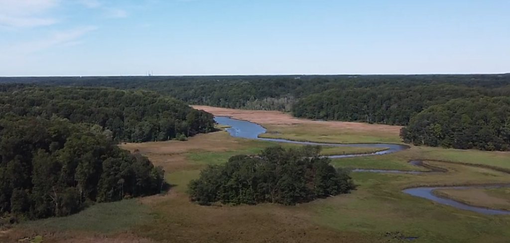
Although part of the mostly gentle Atlantic and Gulf Coast Coastal Plain, the Parkers Creek Preserve (PCP) is scarcely a plain. That’s obvious even to first time ACLT hikers or Parkers Creek canoeists. Our preserved land rises locally to more than +160 ft above sea level, and some ravines are more than 100 ft deep. Adding canopy trees 75 to 140 feet high makes the land look even higher, especially when viewed from out in the Chesapeake Bay. The Calvert Cliffs form a formidable 50-100 ft high eastern rampart for the PCP. The preserve owes its dissected topography—at once as ideal for ecological diversity and nature hikes as it is challenging for farming or development—to the proximity to the Chesapeake of lands well above sea level. Steep gradients empower running water with the gravitational energy to sculpt the land. While Minnesota may be the “Land of 10,000 lakes”, are we the “Land of 10,000 ravines”?
Not just an ecologically resilient ‘bio-preserve’ and nature park, the PCP is also a museum of geomorphology. That’s the study of landforms and the processes that shaped and are still shaping them: the topographic texture on which our living green carpet is draped. We have some interesting land forms, like that mysterious forested mound rising 43 ft above the Parkers Creek salt marsh. Hint—it was not built by ancient Native Americans or modern developers. Parkers Creek itself is a geomorphic oddity—flowing into the Bay when it was originally the middle part of a longer Battle Creek, flowing into the Patuxent.
Mankind is increasingly the main geomorphic agent (think bulldozers), but except for increased erosion caused by pre-modern farming, the PCP has been shaped by nature. However, nature tends to be a slow and patient sculptor of land—the morphing is too slow on our human time scales. In the PCP area, only the Calvert Cliffs and beaches change fast enough for us to notice.
Mapping and Displaying topography
Topography can be shown in different ways. A simple 3-D sketch or a photograph-ideally taken when the leaves are off the common deciduous trees and with some snow on the ground, can provide a local view. Contour maps became common years ago but may be greatly in error! An elevation contour is just a line on a map connecting points of the same elevation. ACLT trail maps have generally shown elevation contours—mostly at 20 or 30 ft contour intervals. Finer contour intervals would show more detail but too much clutter for a paper brochure. To see those details, go online and zoom down! Modern digital representations of topography—as computer illuminated and colored “hill-shade’ images–offer photographic realism, but elevations can’t be ‘read’ as on a contour map. They are useful to hikers but not as useful as contours. Hill-shade images are generally computed from LiDAR (Light Detection And Ranging) scanners deployed on manned aircraft or drones. A laser is scanned (swept) back and forth across the ground at right angles to the flight path and at high rates. Laser pulse reflection times from the ground back to the sensor are measured and converted. Calvert County was first flown with LiDAR in 2005. In my opinion the greatest potential value of LiDAR for ACLT would be mapping forest canopy height—by subtracting laser reflections from tree tops from the ground elevations. A measure of forest type, age and health.
However valuable contour maps are, we humans relate much better to maps showing the ‘culture’ we have written—and keep rewriting– on the landscape. For the PCP that’s mostly roads and trails. We can also relate to ACLT’s ‘virtual culture’—property outlines with diverse colors showing the status of land preservation. We follow the progress of ACLT land preservation on maps which have practically no visible expression on the ground.
I liken this culture (e.g., roads, trails, power lines, buildings, property boundaries, cleared fields, etc.) as well as our natural vegetative cover to a palimpsest. We humans ‘write’ our things on the land by erasing much of what nature has written. And then we may tear down historic buildings to make room for others. Other metaphors include black and white boards or painter’s canvases which, like the vellum or parchment (animal hide) of old– are just too valuable not to reuse. Of course the same is true for land—as our former MD Comptroller and Parkers Creek land owner liked to say about land “God made only so much of it.” Competing uses for the same land are a reason for land trusts like ACLT!
Nature slathers her corrugated canvas—the land– with thick ‘paint’—lush green in summer, more gray and brown in winter, sometimes even white. If you don’t like the ‘paint’ metaphor, how about a living carpet? While ACLT naturally concerns itself mostly with the ‘paint’ (or ‘carpet’), this article is about the underlying ’textured canvas’. But metaphors have limits—paint is not alive and does not derive its sustenance from the ‘canvas’. In fact the soil and subsoil form a living underground world of roots, fungi, bacteria, and burrowing critters.
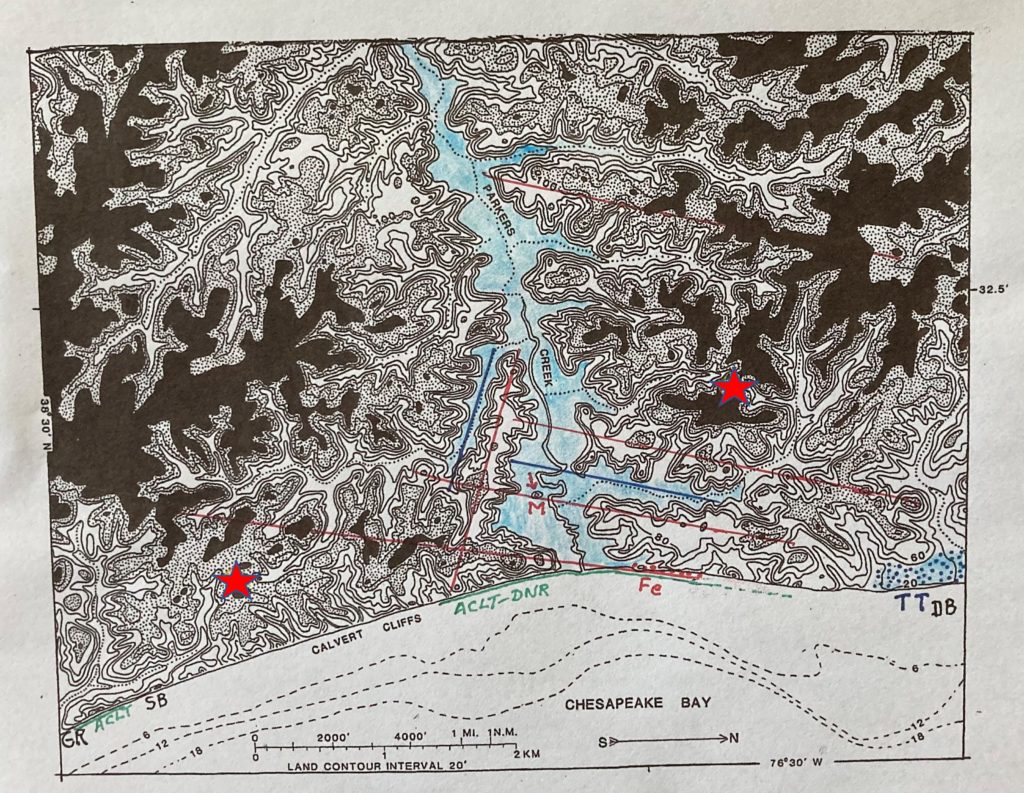
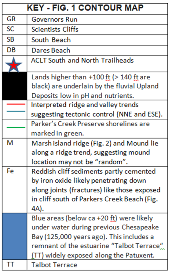
While many ACLT members are familiar with PCP topography from hiking and canoeing, it’s challenging to orient oneself—can you locate your favorite ACLT trail?– on a contour map stripped of culture, particularly roads and trails. Of course we recognize Parkers marsh and the Calvert Cliffs, but where for example is the ACLT South trailhead or Double Oak Farm? To save readers the head scratching, I placed small yellow flowers at those three spots. The Yoe farmhouse sits near the headwaters of a major feeder ravine to Parkers Creek’s longest tributary. Double Oak is near the drainage divide (saddle) between the Horse Swamp creek watershed and a smaller tributary watershed further north. The ACLT South trailhead is appropriately very close to the drainage divide (interfluve) between the Parkers Creek and Governors Run watersheds whose preservation remains our land trust’s focus.
I also labeled that marsh mound (M), and drew some straight lines showing topographic trends of several ridges and valleys. (More about those later).
Land above +140’ is shown black and from +100 to +140 ft stippled. That helps readers orient themselves. A plain contour map-depending on how it is colored—a kind of natural Rohrschach test or paint- by- numbers painting. Coloring selected elevation intervals with a felt tip or crayon can be therapeutic— much slower but more exciting than coloring by computer graphics. Nowadays geomorphologists routinely use computer graphics with different combinations of illumination and coloring to tease out subtle patterns of interest.
When PCP topography is shown this way, it looks dramatic. But modeled to scale in plaster at page size, the relief would only be around 1/16” inch, just enough to feel if you ran your fingers over it.
PCP Ecosystem Diversity and Resilience: Shaped by Topography and Geology
Our topography alone creates ecosystem diversity. North- facing slopes have a cooler, moister microclimate, different from the drier hotter south-facing slopes. Soggy flat valley bottoms support ecosystems distinct from those on flat ridge crests. The salt marsh, freshwater tidal and non-tidal swamps add further diversity, together making the PCP a microcosm of the Chesapeake Bay.
However, PCP topography also has a geologic connection—important for understanding our ecosystems. Where streams dissect a stack of flat-lying sediments or sedimentary rock, the layering is exposed—though maybe draped by soil–in valley walls. Progressively older layers crop out (or “subcrop”) further down the slopes. Of course the younger and higher a layer, the more of it has been lost to erosion. Grand Canyon is a grand example, but the PCP is fundamentally the same phenomenon, but for the smoother and 50 times lower relief. In neither case are the layers perfectly horizontal, but that’s a good approximation.
In contrast with the Grand Canyon- where old rocks are exposed in every side canyon- in the PCP we only rarely see any exposures of the Miocene layers even on the slopes of ravines. The reason is obvious—our Miocene layers were never turned into hard sedimentary rock, as have the ancient layers forming Grand Canyon’s cliffs. However, Miocene fossils are sometimes found in Calvert County ravine bottoms. Groundhogs may dig out of their burrows bits of fossil shells which however eventually dissolve in our acidic soils.
Our Miocene layers are tilted (dip) to the southeast at a few feet per mile. The shell marl exposed to Chesapeake Bay waves at the base of the Governors Run cliff would likely be encountered in a borehole at ca. 15-20 ft above sea level around 120 ft below Double Oak farm, which is about 3 ½ miles northwest of Governors Run. Shell marl is sediment which contains lime—in our case fossil mollusk shells.
The oldest PCP sediments above sea level were laid down 15 or 16 million years ago—around the middle of the Miocene epoch of geologic time- and are exposed near the base of the PCP’s Calvert cliffs. Some of these layers are so cohesive they crack into blocks just as harder rocks would. The youngest of these marine sediments date from around 10 million years and in the PCP are exposed around 100 ft above sea level. A total of three shell marls occur within this 100 ft section and where they intersect the ravine slopes buffer our otherwise acid soils. This geologic buffering is the only way to explain the moderate pH of PCP streams—the pH is well above that of our rain. How well plants can utilize nutrients depends on soil pH! Tulip poplar, spicebush and pawpaw are common forest flora. Botanists have even spotted some PCP wildflower species otherwise known only from limestone substrates of the Appalachians.
Atlantic Retreat Is followed Potomac Advance
Around 8 million years ago the Atlantic Ocean retreated from what is now Southern Maryland. Relative sea levels likely fell, in part due to ice sheet expansion in Antarctica. From then until around 2 or 3 million years ago the Potomac and its tributaries flowed across here on their way southeast to the coast. The ‘fluvial’ (river deposited) sediments have more sand or even gravel, and very few fossils. In the PCP these “Upland Deposits” are present where our land is higher than about +100 ft (stippled or black).
Lacking shell marls and also low in nutrients, the Upland Deposits support flora which do well in more acidic soils—ACLT naturalists can attest that pine, mountain laurel and even oak species are generally restricted to our higher elevations. Sands winnowed from the Upland Deposits by streams work their way downstream and eventually replenish beaches.
The presence of Upland Deposits capping Calvert County shows that the Patuxent must have formed after the Potomac switched its Coastal Plain course at the Fall Line, where it today turns sharply to southwest. Before that switch, the river continued on its SE course it still has across the Piedmont. What caused this course switch (similar in sense to that of the Delaware and Susquehanna) is beyond the scope of this article, but it ultimately initiated formation of the Patuxent River and thus the stream layout on the present PCP.
The Upland Deposits were laid down on a gently sloping plain—like that along the US Gulf Coast today. Remnants of this ancient plain are scattered around in Calvert, including the PCP. The wide field at the intersection of Parkers Creek Road and MD 765 is a great example, and the gently rolling terrain around Double Oak and Holly Hill. Nearly level lands erode also, but only very slowly: Maybe just an inch per 1000 years! The original plain sloped very gently towards the east, but also covered what is now the Chesapeake Bay.
How PCP topography was born: Dissecting the Upland Plain by Headward Erosion
With the new Patuxent nearby, tributaries began to develop by headward erosion towards the west and east. Headward erosion means the tip or ‘head’ of a stream, ravine or gulley propagates upstream, i.e., ‘eats’ its way into the nearly level land. When past Calvert farmers plowed their fields right up to ravine edges, they soon noticed gullies growing into the fields and consuming their land.
As a valley or ravine lengthens, erosion of its margins cause them to widen. If there are any subtle remnants of the original SE flowing streams, I am not aware of them. Thus, the stream pattern we see today on the PCP began with streams flowing into the Patuxent starting very roughly a million years ago—accurate dating is challenging. The streams heading west towards the Patuxent flowed from an upland drainage divide out in (and above) what is the modern Chesapeake. This was the divide between the Patuxent and Susquehanna watersheds. Parkers Creek was the middle part of a longer Parker-Battle Creek. The upland once between the present mouth of Parkers Creek and that divide was lost to cliff erosion. The divide elevation is unknown but had to be above the +45 ft elevation of the remaining short segment –the ‘dry valley’ utilized by German Chapel Road–of the old Parker-Battle stream.
Stream Piracy–How the Chesapeake stole Parkers Creek from the Patuxent
The present PCP topography, dominated by the east-flowing Parkers Creek is of geologically more recent origin but was also caused by headward erosion. This ‘stream piracy’ or ‘inversion’ makes our land unusually interesting but is challenging to explain in words. Cartoons would be better, but a computer animation movie would be best. Any computer-savvy folks want to help me explain how Parkers Creek was stolen from the Patuxent? Such a movie would also cover the SE to SW course switch of the Potomac.
Anyway, here in words: We have had a succession of Chesapeake Bays, and each one caused more upland loss by cliff erosion. The penultimate Bay, ca. 125,000 years ago, had sea levels around 20 ft above today’s. When cliff erosion- perhaps from an even earlier Chesapeake Bay- first passed the old Patuxent-Susquehanna drainage divide, it was easy for an infant east-flowing stream to ‘eat its way’ upstream (headward erosion) along the channel of Parker-Battle Creek. Steeper gradients empowered young Parker’s Creek. The existing channel fill was soft and a valley already existed. How long it took for the new Patuxent-Chesapeake divide, i.e., the headwaters of Parkers Creek, to migrate to where it is today, crossed by German Chapel Road, is unknown. I estimate that the piracy began as late as 150,000 years ago— we humans already existed but had not left Africa.
Although inherited from a tributary to the Patuxent, the Parkers Creek watershed is more deeply dissected today than a million years ago. The upland plains have shrunk to scattered patches and the ravines have become deeper. Much of these changes have happened in the last 600 thousand years—with their large alternations of high and very low sea level.
Thus, all of the present Parkers Creek watershed once drained west into the Patuxent. The Parkers tributary streams of course did not change direction, and the overall pattern of streams and ravines has not changed. However tributary stream and ravine gradients have been increased—and are still increasing as the cliffs continue to migrate west, locally slowed by human shoreline protection.
The steep gradients give stream water more energy to cut into the substrate and cut inland by headward erosion. As the cliffs retreat westwards, the Chesapeake Bay steals land from the Parkers Creek watershed: The present strip of land about 500 to 2000 ft wide (the Warrior’s Rest cliffs and much of Scientists Cliffs) now drains directly into the Bay. For example, the north fork of Governors Run (colored yellow) flows south parallel and just 350 ft inland from the cliffs. Absent human tampering, shoreline westward retreat by the Bay would capture this fork in just around 2000 years. Whether rejuvenated ravines pirated from the Parkers watershed, or brand new, these short ravines make up for their tiny watersheds with high energy, locally even forming small waterfalls during cloudbursts. Arresting shoreline retreat won’t stop the Bay from stealing more land from the Parkers Creek and Governors Run watersheds.
Farming activities by English colonists and their American descendants accelerated erosion of the Upland Deposits, particularly by the headward erosion of ravines. Many of these formerly active gullies are now stably forested.
The Parkers Creek Marsh Mystery Mound
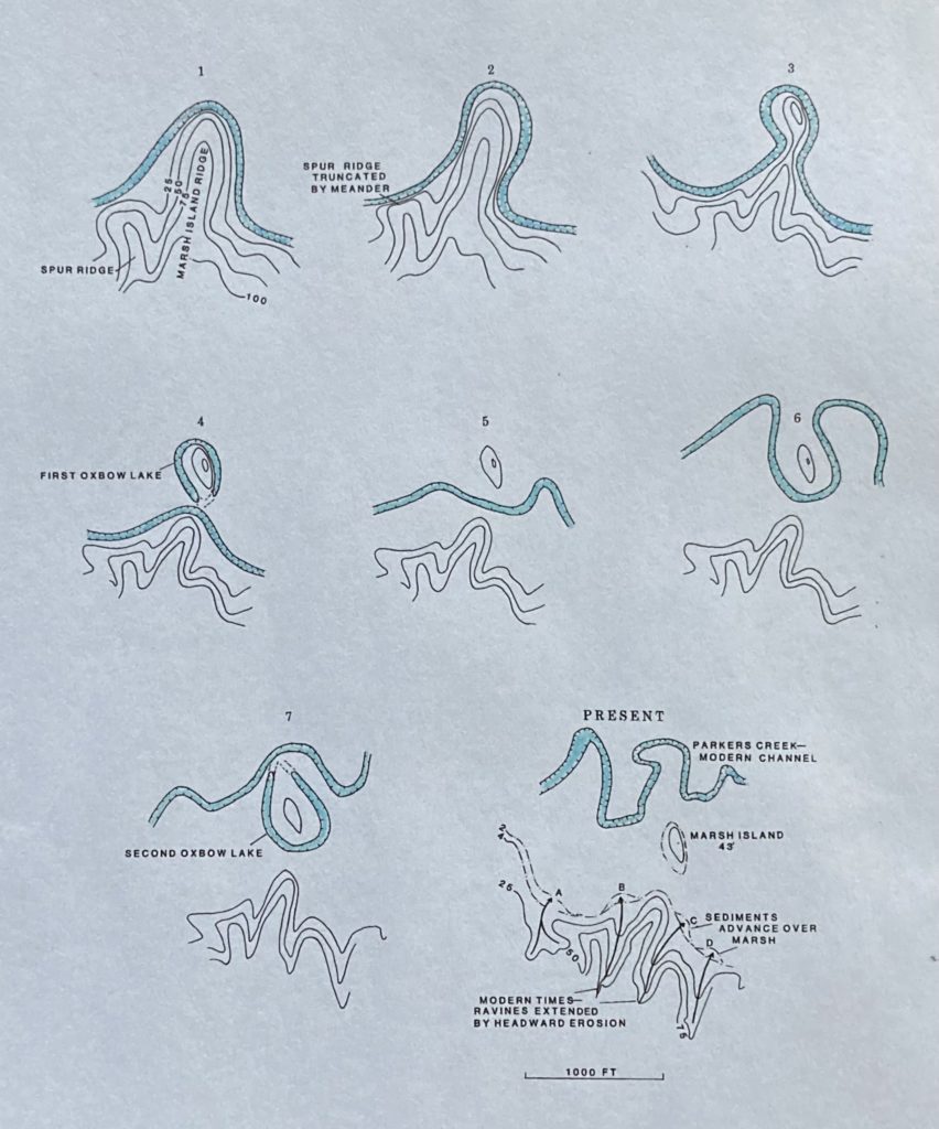
The most unusual topographic feature in the Parkers Creek Preserve is an elongated mound or island rising about 43 ft above from the surrounding salt marsh. Trees covering the mound may increase its total height to more than 100 ft. ACLT canoeists notice this on their first trip up the creek and might wonder if it was made by humans, for example by ancient Native Americans. However, there were no mound-building cultures here, and no evidence for an artificial origin. However, who’s to say the mound was never used as a lookout by scouts or hunters? The mound might have been made by past Parkers Creek meanders and meander cutoffs—forming intermittent oxbow ponds. Alternatively, it may have formed by shoreline wave erosion during times when there was no marsh and no barrier beach. While the marsh mound looks to be a remnant of a formerly longer marsh island spur ridge, it’s strangely oriented in another direction: NW-SE. This shape might reflect past meanders but alternatively was caused in the absence of marsh and barrier beach by shoreline erosion from Bay or lagoon waves eroding its shores from the northeast.
The PCP Is About Water
Water seems nearly the sole common denominator for what shaped and continues to shape the Parkers Creek Preserve (I said ‘nearly’—read on). Waters of the Chesapeake Bay gnaw at the cliffs slowly replacing our dissected uplands with a very gentle estuarine floor. Of course this only happens during interglacial warm periods with high sea levels, most recently the last 6000-7000 years. At other times the cliffs stay put as wooded escarpments.
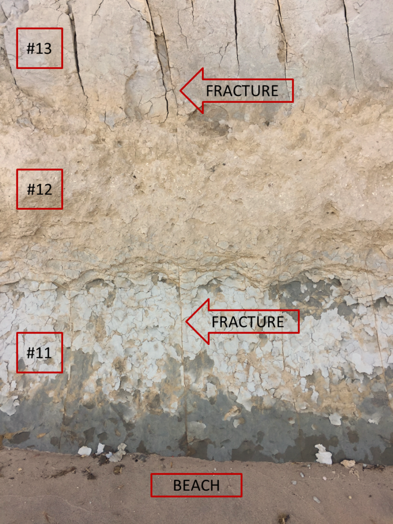
Pore water trapped in Miocene cliff sediments helps erode them by freeze and thaw in winter. Rain water washes sediment into the ravines and then into the Bay. Protracted rains soak into the ground, causing landslides on steep slopes. Cohesive Miocene sediments are fractured, letting water seep along joints, helping loosen blocks but locally carrying dissolved iron down as cement to strengthen the sediments (cliffs north of Parkers Creek beach). All the sediments eroded from the PCP and carried to the Bay had already been carried there by water—the Miocene sediments in the Calvert Cliffs and present everywhere below about +100 ft were deposited from Atlantic Ocean waters. Sediments comprising the ‘Upland Deposits’ were brought here by the ancestral Potomac.
A Touch of Tectonics– Any PCP topography with structural control?
Is anything about our PCP topography NOT caused by the actions of water? Maybe so, but subtle. Stream patterns developing and growing on uniform sediments produce the familiar dendritic patterns like the veins in a leaf. The two large PCP tributary watersheds south of Parkers look pretty dendritic.
When geomorphologists look at accurate topographic maps, they keep an eye out for “structural control”. By that they mean faults or folds or even simple fractures (joints) that may have influenced the pattern of streams. For example, a fault in older deeper rocks might have become reactivated and propagated up into the overlying sediments and fractured them. The headward erosion of a stream would follow such a zone of weaker, more easily erodible sediment. Or, if groundwater had seeped down along a fault zone or joint system and deposited iron oxide, these sediments would be more resistant, avoided by a growing stream. In a landscape dominated as the PCP is with dendritic drainage patterns, a search for ‘structural control’ involves looking for longer straight valleys or ridges and regularities in trends and spacing. However not all faults are linear—a rising salt dome or a subsiding crater could have patterns of circular faults. If there is too much dendritic stream topography, structural control might not be recognizable, or people would argue about its existence. It’s a matter of ‘signal to noise’. We humans are great at pattern recognition, but we are also prone to see things not really there.
Let’s now first take some steps back and look at the geology of our region. Coastal Plain geology, even our dissected PCP, seems pretty boring compared to the western US. That’s because we sit on a passive continental margin, which, since plate tectonics separated North America from Africa around 175 million years ago has been very peaceful. Our margin is slowly subsiding and accumulating erosional detritus—sediments—eroded and weathered from the Piedmont and Appalachians. Under the PCP lies about a half mile of shallow marine or marsh sediments—the oldest below us were laid down around 125-150 million years ago. That’s the long term subsidence—averaging about one foot per 50,000 years. A rate trivial compared to our present sinking rate—one foot per 300 years—the delayed response to the “recent” great Laurentide ice sheet and its melting. The part of our relative sea level rise we can’t change but which will continue at slowly decreasing rates (discussed in Quo Vadis article).
However passive the continental margin, our plate interior has been under horizontal compressive stress beginning soon after we separated from Africa. Due to the slow stress buildup, our strong crust, and the stress being compressive, it takes many centuries or even millennia before there is enough stress to break the rock and thereby produce an intraplate earthquake, but when one happens, it is felt over a much wider area (less attenuation of seismic waves in old crust) than a comparable one on the West Coast.
The 2011 Louisa, VA quake (magnitude 5.8) was clearly felt here in Calvert, as was the 7.0 shock that destroyed Charleston, SC in 1886. If cliffs are shook in a strong earthquake, landslides can happen, so seismicity can be a geomorphic agent. As far as I know, the Louisa shock did not cause landslides along our Calvert Cliffs—it was close but not close enough. The Charleston quake was much too far away but I doubt anyone checked the Calvert Cliffs for new landslides.
The Louisa shock occurred in the Piedmont and the Charleston one on the Coastal Plain, but they both involve reverse motion on steeply dipping reactivated faults. Reverse fault motion involves one side shoved up over the other. Closer to Calvert, the Stafford faults in Virginia and the Brandywine fault system under Charles County, as well as the fault under Louisa, are also reverse faults. They most all trend (strike) NE to NNE. In all these cases, ancient preexisting faults were reactivated. The faults remained as zones of weakness—where repeated breakage is most likely. (Anyone who breaks apart wooden furniture notices that breaks often follow old glue lines or other joinery). The faults under Louisa and Charleston had been normal faults (extension) as preludes to formation of the Atlantic by plate tectonics. Long before that, the same faults had been involved in the continental collisions of the Appalachian orogenies (mountain building episodes) that closed an earlier ocean from 500 to 250 million years ago.
There can be little doubt that the ancient crystalline and metamorphic rocks a half mile and more below Calvert County are criss-crossed by earthquake faults and other structures. While modern technology is more than adequate, who would pay for a number of boreholes to learn more? Whether, where or how often any of these faults could rupture again is unknown, but if faulting happens, it must be very rare. However, the buried Taylorsville Basin across northern Calvert County, formed around 225 million years ago, is bounded on one side by a NNE trending fault similar in age and trend to those mentioned above which have ruptured in more recent times. The Miocene sediments exposed in the Calvert Cliffs (laid down from 18 to 8 million years ago) are not offset by faults except at one site along the southern cliffs. A high angle reverse fault has offset the Miocene layers so must have been active until at least 8 million years ago. It is unknown whether younger Upland Deposits were also offset. The trend of this “Moran’s Landing Fault’ remains unknown, but given its location between the LNG terminal and the nuclear power plant should be investigated.
Even in the absence of faults (with displacements) crustal stress can create patterns of simple cracks, called joints. Topography can offer clues—any evidence for ‘structural control’ in PCP topography? I think so, but the evidence is subtle. Some of our lower Parkers Creek watershed topography, although much carved out by water, seems too linear to have been created entirely by water- I drew ridge lines in red and valleys in blue. Possible structural control guiding the original courses of streams. There appear to be two main trends, at right angles to each other: A NNE trend and an ESE trend. These lineations are somewhat regularly spaced—about 1500-2000 ft apart. One of the NNE ineations is that half-mile long ridge just east of Double Oak.
One NNE ridge trend happens to align with the Parkers mound and associated spur, both relics of former higher and wider features. Maybe the location of this mound was not solely the work of stream erosion and meanders. When the most conspicuous (and most easterly) ridge trend is extrapolated, it grazes the cliffs north of Parkers Creek. The sediments in the lower parts of those nearly vertical cliffs are very cohesive, with joints locally cemented by iron oxide. A clue that dissolved iron percolating down along joints and precipitating in the Miocene sediments may have been a reason for this ridge. Maybe.
Tectonic origin of regular cracks (fractures or joints) in the cliffs?
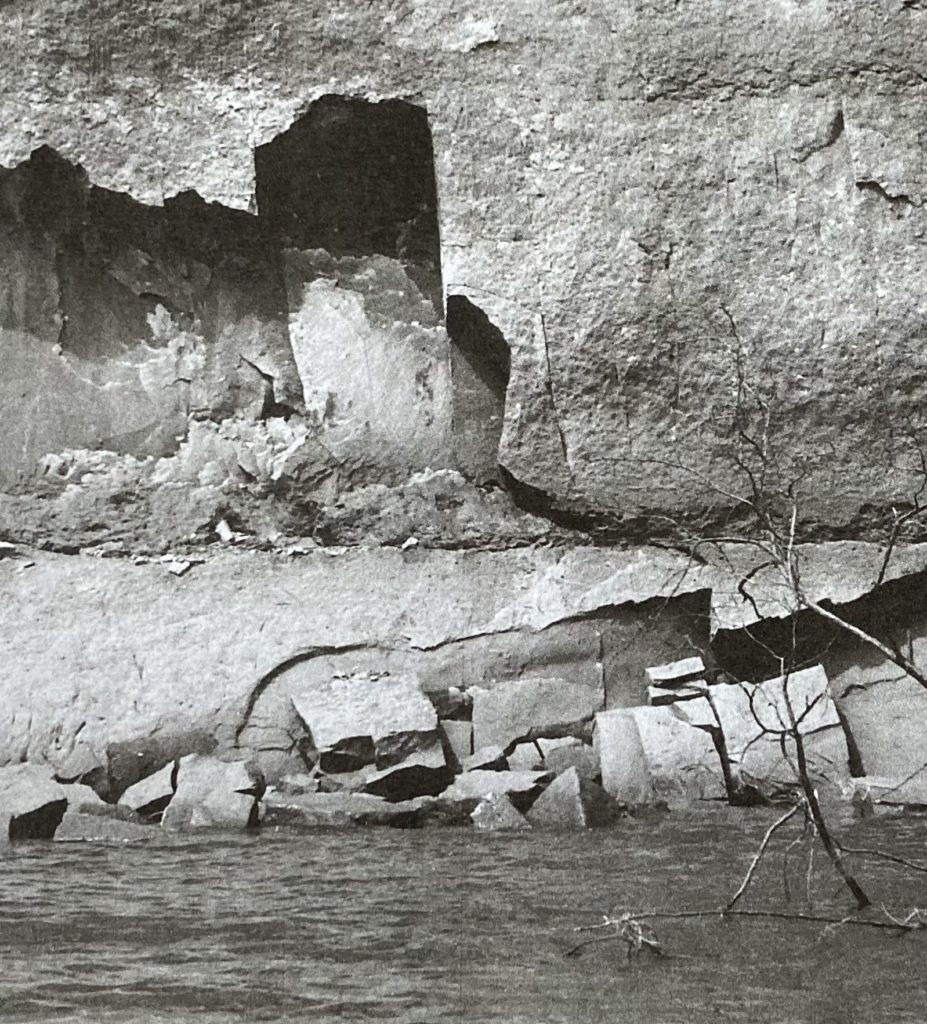
Any independent evidence for NNE and/or ESE trending structural trends? Maybe. The lower, most cohesive layers in the Calvert Cliffs exposed in the PCP just south of Parkers Creek beach have been fractured by some process. Modern cliff erosion is in the form of blocks caving off along those fractures. There are numerous such joints spaced regularly around one foot apart, steeply dipping. The trends (strikes) are hard to measure accurately but appear to be E-ESE. These joints may have formed by thermal contraction and extension during the annual air temperature cycle, but if so would not continue deep into the cliff. If the joints are tectonic, they would extend through the ground under the cliffs. Some of the block failures may be controlled by NNE trending joints, but any cliff naturally fails along cliff-parallel joints. Whether or not these two sets of joints and resultant block collapses are partly of tectonic origin, they represent geomorphology processes working fast enough for humans to study.
It’s likely but not proven that sediment layers under the PCP have been fractured (by long term horizontal intraplate stress) along the well known regional NE to NNE structural trends. When our tributaries to Parker-Battle creek first formed, they would likely have propagated in one direction by headward erosion along zones of sediment weakness such as fractures (joints) or even, at depth, minor faults.