ACLT Opens a New Hiking Trail
- ACLT American Chestnut Land Trust
- Apr 27, 2017
- 1 min read

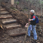
Running from the end of the Parkers Creek Road trail on the North Side, across the creek, then winding a challenging 2 miles to Cemetery Lane on the South Side, ACLT’s new "North-South Trail" is a remarkable and fun addition to our trail system! See our complete trails map.
We’ve worked hard and are so excited to launch this new experience at the Parkers Creek Preserve! The trail has two features that make it particularly interesting:
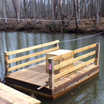
--The Raft! ACLT volunteers and staff have spent months designing and building a safe and fun way to cross Parkers Creek. Safely climb aboard the raft and pull yourself and a few friends from one side to the other!
--It’s our toughest trail yet! We’re listing it as difficult to challenging.
Find the new “North-South Trail” on the map of ACLT’s 22 miles of self-guided hiking trails. You can view and download the trail map as a PDF file. The map of ACLT’s trails is also available at ACLT’s trailhead locations. Read more about exploring ACLTs land under the “Land and Maps” menu tab.
GET TO THE RAFT: The easiest way to get to the raft is to take Old Parkers Creek Rd Trail from North Side Trailhead. Check out the map with details here


Comments