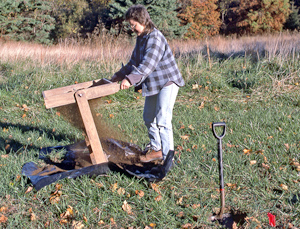
A number of sites of historic interest stand on land owned or managed by the ACLT. Some sites are visible to visitors from the ACLT trails. Although these sites may be viewed from the trails, visitors are cautioned that none of the buildings are safe to enter. Visitors are also reminded that ACLT rules prohibit collection or removal of anything from ACLT owned or managed properties. For more information about sites that are located on lands managed by ACLT where access is limited, contact the ACLT office: 410-414-3400; info@acltweb.org.
Prehistoric sites
Archeological investigations in 1997 and 1998 identified a number of prehistoric sites. In some of these, identifiable materials—often chips of stone from tool-making—were found in test diggings, indicating human use of the land in the Late Archaic period (3000–1000 BCE), the Terminal Archaic period (1000 BCE), and the Early Woodland period (1000–300 BCE). The photograph shows an archeologist sifting through the dirt from a shovel test pit.
South of Parkers Creek
Sites on ACLT-owned Land and Trail System
(These sites are accessible when trails are open.)
Percy Howard Farm
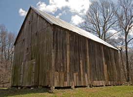
Members of the Howard family lived on what is now Scientists Cliffs Road from 1886 until 1937. After John Howard died in 1891, the original family farm was divided between his sons, Percy and Emory. Percy's farm, on the west side of the road, included the two former tobacco fields at the land trust's south trailhead as well as land to the north. In 1924, Percy Howard sold his farm to Marmaduke White, who owned it until 1935, when he sold it to Annie and Flippo Gravatt. White did not occupy the property but arranged for the land to be farmed and built the barn in the photograph. Meanwhile, Emory Howard sold his farm to Annie Gravatt in 1937, and it became part of Scientists' Cliffs.
ACLT volunteers repaired the Howard-White barn on stray weekends from 2003-2008, and the project received a Calvert County historic preservation award in 2009, as described in the Summer 2009 Newsletter. Still to be seen: the repaired tobacco barn, ruins of a shed destroyed by hurricane Irene in 2011, cellar hole from former dwelling. Also of note is a segment of the old road just east of the barn, narrow and with high banks indicating many years of movement by people, livestock, and farm wagons.
Lemuel Wallace Farm
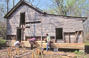
Former home of an African American farm family that owned about one hundred acres from 1909 until the mid-1930s. Lemuel Wallace's grandson, Woodrow Wallace, reported that the farmstead had once included a number of outbuildings and that water was carried up the hill from a spring. In 1990, the ACLT moved a log corn crib to this property from a farm on Barstow Road west of Prince Frederick. Members of the Wallace family live nearby and cultivated tobacco on the fields at the ACLT's south trailhead through the 2000-01 season. The photograph shows volunteers repairing the house. Still to be seen: house, ruin of barn on the hilltop above the house, log corn crib.
Hance-Chesley Farm Cemetery
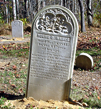
The farm at this site was occupied by different families over the years, including some individuals buried in the cemetery on the property. The house site is now nearly invisible in the woods nearby. The cemetery includes the graves of Benjamin Hance (1755–1812), his son Young Dorsey Hance (1791–1855), and Y.D.'s first and second wives, the sisters Henrietta Maria Chesley (1794–1821) and Elouisa Ann Chesley Hance (1799–1849). Y.D. Hance bought the "Taney Place" on Battle Creek (7 miles to the west, and the birthplace of Chief Justice Roger Brook Taney) in 1835 but his remains were brought back to his old home for burial. The ACLT and the Calvert County Garden Club have made a number of repairs and improvements to the cemetery, winning a Calvert County historic preservation award in 2005. The Hance-Chesley Cemetery Brochure provides additional information. Still to be seen: cemetery, house site (little remains).
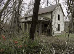
Commodore-Harrod farm
Former home for the African American farmer Clarence Commodore, his wife Henrietta, and their children. The Commodores purchased the twenty-acre farm in 1943 and later passed it on to their heirs. The house and barn, both now abandoned, stand on the remaining portion of the original 20 acres. The house consists of an older two-story section (about 16x18) and a new story-and-half addition (about 16x16), and a kitchen ell. The frame barn has doors on all sides and was used to cure tobacco, including crops grown on ACLT-owned land as recently as 2000. Still to be seen: house and barn.
Sites on Maryland State-owned Land
(These sites are only accessible when Warriors Rest is open for events.)
Warriors Rest Farm
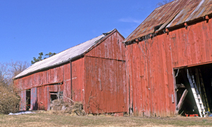
Farm owned by different members of the extended Hance family during the nineteenth century, with some intervening ownership. Local tradition associates the property name with one or another returning veteran of the War of 1812 or the Civil War. The original house and outbuildings are gone; the older part of the current house is probably from first half of the twentieth century and the larger, newer part from about the 1960s. The two barns (shown in photograph) date from the 1940s or 1950s. From 1955–1990, the property was owned and occupied by the physician Page Jett, who used the small cement-block building near the house as a doctor's office. Still to be seen: house, barns, doctor's office.
William Commodore Farm
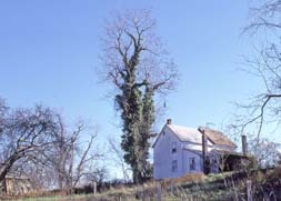
Farm owned and operated by an African American family. William H. Commodore, born in 1861, bought the property from Y. D. Hance (great-grandson of the Y.D. Hance buried nearby) in 1898. In 1947, this farm was purchased by the then-owner of Warriors Rest and, for the next fifty years, it served as a farm-tenant operation. Like many Calvert County rural buildings, the house is sited on high ground where it catches the cool breezes of summer. Still to be seen: house and nearby large apple tree.
Parkers Creek Pound Net Fishery
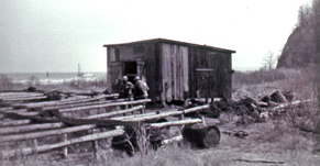
Captain Frank Richardson, a waterman from the Eastern Shore, operated pound nets-weir-like traps designed to catch finfish-near the mouth Parkers Creek from the 1930s to the 1950s. When working, the nets were stretched between stakes or pilings driven into the Bay bottom. When idle, the nets were laid on racks on the beach and tar was applied to protect the fabric, as shown in the snapshot. The only remaining building at the site is a small board-and-batten shed, now in deteriorating condition. Still to be seen: shed.
North of Parkers Creek
Sites on ACLT-owned land and trail system
(These sites are accessible when trails are open.)
Simms or Scales Farm
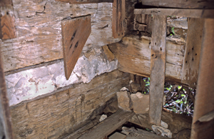
Former residence of one or more African American families; the details of its history are not known. The families associated with the property are named Kelly, Scales, and Simms. The house (now a ruin) was in two parts: a log portion (presumably older) and a frame portion (presumably newer). The logs had been cut into slabs and chinked with local ironstone and mortar, as shown in the photograph. Still to be seen: ruin of the house.
Ward Barn
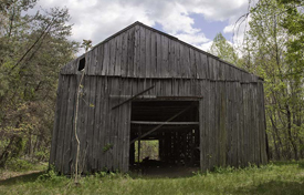
Twentieth-century tobacco barn with stripping room. The barn stands on a 115-acre tract purchased in 1995 from the physician Hugh W. Ward by The Nature Conservancy. Ward obtained the land in 1934; the prior owner was Arabella Wallace. Still to be seen: barn with tobacco stripping room.
Site on Maryland State-owned Land
(This site is accessible only when special events have been scheduled.)
Bayside Farm.
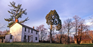
Farm owned and operated by the Chambers family until the 1890s. About ten years later, it was purchased by a Baltimorean who owned the property until 1949, when it was purchased by Louis Goldstein (a Calvert County native and Maryland political figure). Both of those owners rented the land to local farmers. About 25 acres of arable land are still farmed by Wilson Freeland, a neighbor and third-generation descendant of a former farmer on this property. The house, shown in the photograph with one of the barns in the background, is listed on the Maryland Inventory of Historic Sites (CT497). Still to be seen: house, two timber-frame tobacco barns (probably nineteenth century), one modern tobacco barn (mid-twentieth century), ice house, corn crib (repaired as an ACLT-Boy Scout project), tobacco stripping shed, farm implement storage shed, and other small sheds.
On Parkers Creek
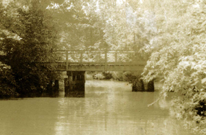
Former Parkers Creek Road Bridge.
Parkers Creek Road ran from Port Republic north to an intersection with the road to Dare's steamboat wharf (now Dare's Beach Road). The Parkers Creek road and bridge lasted until the late 1930s, by which time the increased availability of automobiles and the existence of better, albeit less direct roads, meant that people could reach the county seat by going west and then north, via the county's main road, today's Maryland state highway 2-4. This photograph from the Scientists' Cliffs Association Archives shows the bridge at some point between 1937 and 1945, before it was abandoned and allowed to collapse. Still to be seen: pilings from the old bridge visible from the Parkers Creek Loop Trail, accessible from ACLT's north trailhead.
Prehistoric Sites
South of Parkers Creek
- Sites on ACLT-owned Land and Trail System
- Percy Howard Farm
- Lemuel Wallace Farm
- Hance-Chesley Farm Cemetery
- Commodore-Harrod Farm
- Sites on Maryland State-owned Land
- Warriors Rest Farm
- William Commodore Farm
- Parkers Creek Pound Net Fishery
(Only accessible when Warriors Rest is open for events.)
North of Parkers Creek
- Sites on ACLT-owned Land and Trail System
- Simms or Scales Farm
- Ward Barn
- Site on Maryland State-owned Land
- Bayside Farm
On Parkers Creek